
SCHOODIC NATIONAL SCENIC BYWAY
CORRIDOR MANAGEMENT PLAN
Prepared for the Corridor Advisory Group and the Maine Department of Transportation
By The Route 1 and Route 186 Corridor Planning Group and
The Hancock County Planning Commission
With financial assistance from the National Park Service and the Maine Department of Transportation
(Revised: 5/2/99)
jhf c:\my documents\transportation\byway\rt1\doc\rt1cmp04.doc
CONTENTS
SCHOODIC SCENIC BYWAY - CORRIDOR MANAGEMENT PLAN *
SUMMARY *
WHY A BYWAY? WHY THIS BYWAY? *
WHAT�S IT LIKE? TRAVELING THE SCHOODIC HARBOR BYWAY *
A BRIEF HISTORY
*OUR LIGHTHOUSES AND OTHER HIGHLIGHTS
*A GUIDED TOUR
*WHERE ARE WE GOING? A VISION AND GOALS *
VISION
*GOAL 1: maintain and enhance the scenic and historical value of the Scenic Byway
*GOAL 2: provide safe traveling lanes for pedestrians, Bicycles and Motor vehicles
*GOAL 3: Foster Participation And Community Support For The Scenic Byway
*GOAL 4: Promote Education On The Need For Resource Protection And Preservation
*GOAL 5: Support Year-Round Economic Growth AND Seasonal Tourism
*WHO IS COMING WITH US? BYWAY PARTNERSHIPS *
CORRIDOR ADVOCACY GROUP
*Community Participation Program
Stakeholders and Partners
*Public Relations / Marketing in the Communities
*ONGOING MANAGEMENT AND ORGANIZATION
*THE CORRIDOR MANAGEMENT COMMITTEE
*Affiliations and Responsibilities
*THE ROLE OF LOCAL COMMUNITIES
*Board of Selectmen
*Planning Board
*THE ROLE OF PUBLIC AGENCIES / INSTITUTIONS
*Federal
*State
*County
*THE ROLE OF PRIVATE BUSINESS
*THE ROLE OF COMMUNITY ORGANIZATIONS
*HOW DO WE GET THERE? *
PROTECTION TECHNIQUES FOR LONG-TERM MANAGEMENT
*Zoning, Reviews, Incentives and Voluntary Agreements
*Plans and Ordinances
*Sullivan
*Gouldsboro
*Winter Harbor
*Future Byway Protection Techniques
*MARKETING THE SCHOODIC SCENIC BYWAY
*ARE WE ALMOST THERE YET? A SIX YEAR ACTION PLAN *
GOAL 1: maintain and enhance the scenic and historical value of the Scenic Byway
*GOAL 2: provide safe traveling lanes for pedestrians, bicycles and motor vehicles
*GOAL 3: Foster Participation And Community Support For The Scenic Byway
*GOAL 4: Promote Education On The Need For Resource Protection And Preservation
*GOAL 5: Support Year-Round Economic Growth And Seasonal Tourism
*Summary of Action Plan
*REFERENCES *
LIST OF FIGURES
Figure 1Schoodic Scenic Byway Map
*Figure 2 Trails map of Tunk Mountain and Donnell Pond Public Lands
*Figure 3 Acadia National Park Map
*Figure 4 Historic Resources Along the Schoodic Byway
*Figure 5 Sullivan Land Use Map
*Figure 6 Gouldsboro Land Use- First Section
*Figure 7 Gouldsboro Land Use - Second Section
*Figure 8 Winter Harbor Zoning Map
*Figure 9 Scenic Byway Proposed Enhancements
*LIST OF PHOTOGRAPHS
Photo 1 Route 1 Gateway Logo
*Photo 2 Reversing Falls
*Photo 3 Sullivan Harbor
*Photo 4 Simpson House
*Photo 5 Stone Store
*Photo 6 Long Cove
*Photo 7 Autumn Blueberries and Black mountain
*Photo 8Jones Cove
*Photo 9 Henry's Cove
*Photo 10 Acadia National Park
*Photo 11 Prospect Harbor
*LIST OF TABLES
Table 1 Summary of Historic Buildings and Sites (#'s Correspond to map that follows)
*Table 2 Corridor Advocacy Group Membership
*Table 3 Stakeholders and Partners
*Table 4 Summary of Public Meetings and Events During 1999
*Table 5 Corridor Management Committee - Members for 2000-2001
*Table 6 Sullivan Ordinances and Regulations
*Table 7 Gouldsboro Ordinances and Regulations
*Table 8 Winter Harbor Ordinances and Regulations
*Table 9 Summary of Comprehensive Plans and Protection Techniques
*Table 10 Summary of Action Plan
*
SCHOODIC SCENIC BYWAY - CORRIDOR MANAGEMENT PLAN
The Schoodic Scenic Byway Corridor Management Plan is submitted to advance the portions of Route 1 and 186 from eligibility to designation as a Scenic Byway. This plan is the result of a community effort including members of the Corridor Advocacy Group, the Schoodic Peninsula Chamber of Commerce, Schoodic Futures, planning boards, select boards, local historical societies, clubs and associations. The Towns of Sullivan, Gouldsboro and Winter Harbor recognize the important linkages between their unique scenic resources, the environment, safe and efficient transportation infrastructure and economic development.
The byway starts on Route 1 at the Hancock-Sullivan Bridge and follows Route 1 to the intersection with Route 186 or Jones Cove in West Gouldsboro. The byway then follows Route 186 through Winter Harbor taking a right turn onto Moore Road which becomes Schoodic Road through the Schoodic portion of Acadia National Park. Schoodic Road returns to Route 186 in Birch Harbor and continues on to Prospect Harbor.
This plan poses a series of questions, much like those a child poses when confronted with an extended family automobile touring vacation. Why are we going there? What are we going to see? Who is going with us? How are we going to get there? Are we almost there yet?
A Scenic Byway through the Route 1 and Route 186 corridor will benefit the host communities and visitors from away. The communities are working toward unprecedented levels of inter-town cooperation. The partnership of three towns and Acadia National Park, connected by their unique geography and colorful history, generates new opportunities and resources for helping the economies to grow, conserve natural resources, and improve the quality of life. Visitors benefit by having a beautiful vacation with pounding surf, saltwater estuaries filled with life, historic homes, and a glimpse into the lives of lobstermen, clam and worm diggers, wreath makers, blueberry growers and other resourceful Maine Yankees.
Are we halfway there yet? The Schoodic Scenic Byway is passed the halfway point. The early stages of community organizing, eligibility proposals and now completing our corridor management plan testify to more than two years of effort. In order to get there community members, elected leaders and supporting organizations have prepared a plan that indicates community priorities for resource conservation, byway improvements, information for visitors and safer access to scenic areas. The plan describes how communities will work to preserve their unique endowments and how they will share them with visitors without the damage visible in many formerly scenic regions of Maine. Have we arrived? No, but with support from the Maine Department of Transportation and the Federal Highway Administration we�ll soon be there.
Northeastern Maine is truly one of the last frontiers in United States. This region has many protected public lands and private lands that are maintained in open space and agriculture. Historically, Route 1 has been a heavily traveled byway from Florida to Maine following the coastline. Many settlers from Europe landed in the harbors and developed villages. In this region, generations have lived off coastal resources and made their living trading goods along the main artery, Route 1.

The new bridge over Taunton Bay beginning our scenic-byway is a gateway to Downeast Maine. This part of northeastern Maine remains unspoiled and represents the "real" Maine that residents want to preserve and visitors hope to experience. The concept of this corridor being the gateway to Downeast Maine has taken form in the use of a "Gateway Grant" to place a carved wooden map showing the Downeast Route 1 Trail with the new DOT logo. This gateway serves to promote all of northeastern Maine, bringing much needed economic benefits to eastern Hancock, Washington and Aroostook Counties.
The Schoodic byway is an effort to protect natural and scenic resources and manage tourism at sustainable levels so that the townspeople enjoy the benefits of tourism without feeling over-run. Residents are concerned about the possible impacts of uncontrolled development that has obscured once historic and scenic qualities in other parts of Maine. If development is to occur, it should benefit local families and businesses not act to undermine their well being.
Two themes that really distinguish this byway from any other are the working landscape and tremendous scenery. This plan seeks to balance the need for economic development in the region with protection against the loss of traditional occupations in resource-based industries and protection of the spectacular view along the byway. These two themes will be emphasized throughout this corridor management plan.
Unlike other parts of Maine that have been developed with intensive, tourism oriented businesses, the proposed scenic byway passes through a working landscape of lobstering, clamming, blueberry barrens, timberland and home-based entrepreneurship. Locally produced goods made by artisans and crafters are sold through small shops and yard sales. Along the Schoodic Scenic Byway one can find historic lodging as bed and breakfasts, cabins and campgrounds. Local businesses have changed over the years, but preserve the tradition of small entrepreneurs.
The scenery along the proposed byway is unmatched. The byway passes through villages and waterfronts, including Sullivan Harbor, Winter Harbor, Birch Harbor and Prospect Harbor. Visitors to the scenic byway can observe Taunton Bay, Preble Cove, Reversing Falls, Frenchman�s Bay, Mill Pond, Long Cove, Flanders Stream and Flanders Bay, Jones Pond, Jones Cove and open views of the Atlantic Ocean. In addition to eleven different bodies of water, there area views of mountains, islands, fields of blueberry, wildflowers, ducks, eagles, osprey, historic buildings and light houses and more
WHAT�S IT LIKE? TRAVELING THE SCHOODIC HARBOR BYWAY
During the last Ice Age a glacier thousands of feet thick swept down from the north and scraped the landscape into its current shape. As you look at Mount Desert Island from the Gouldsboro Peninsula you can see the gentle northern slopes and steep southern slopes of the mountains that illustrate that shaping. The rocky soil and many gravel pits are the residue left when the glacier melted. The glaciers also laid bare the unique pink granite that underlies most of the area.
The earliest inhabitants were small groups of Indians who settled here several thousand years ago. A staple of their diet was the clams which could be easily dug from the mud and sand in the tidal flats. Because clamshells can take thousands of years to deteriorate, the buried mounds of shells that are revealed by shore erosion still mark those sites. Most sites are on private property but some are in the Schoodic section of Acadia National Park. Specific locations are not identified in order to reduce vandalism and theft.
The earliest Europeans here may have been Vikings who briefly visited about a thousand years ago. The first documented visits were those of Portuguese, English, Spanish and French explorers who mapped the coast in the early 1500s. Frenchman's Bay, between Mount Desert Island and the Gouldsboro Peninsula, got its name when English sailors saw (and avoided) a French man-of-war moored there. Great views of the bay can be seen from Route 1, Route 186 and Schoodic Point.
Although Indians lived in the area of the proposed scenic byway for thousands of years, there was no organized European settlement until the end of the French and Indian Wars around 1760. "Sullivan was originally called Adowaukeag or Waukeag by the Indians who were in this area when the white people first began to settle here. The name means a "horseback" or glacial kame in both the Penobscot and Maliseet languages. Until the place name could be identified, no one knew where the boundaries of De La Mothe-Cadilac�s grant were. The name indicated the great tidal stream from Sullivan Harbor that fills Taunton, Egypt and Hog Bays and specifically, Falls Point, where the glacial kame crosses the river. The name Waukeag indicated "a horseback in a place where the tide runs out very strong." (Sullivan Town Crier, June 1999) Settlers from southern Maine, New Hampshire and Massachusetts began moving into this area to harvest the trees that they turned into lumber and shipped to Boston. Gouldsboro, including Mosquito Harbor (now known as Winter Harbor), was incorporated in 1789. Winter Harbor seceded and was incorporated in 1895. Sullivan, which originally included what are now Hancock and Sorrento, was incorporated in 1789. Hancock and Sorrento separated and incorporated in 1828 and 1895 respectively.
The economies of the Sullivan, Gouldsboro, and Winter Harbor area developed much like other coastal communities throughout the Downeast region. The people worked primarily as fishermen, lumbermen, carpenters, shipbuilders, seafarers, and tradesmen. People farmed only as a supplement to these other businesses and occupations. Some small-scale gold and silver mining occurred in Sullivan and Gouldsboro, and granite quarrying played an important role in Sullivan. The area still contains many sites illustrative of its historic and economic development.
Typical of small coastal communities, each town had several villages. Each village generally had its own grammar school, church, general store, mill, and post office. Some villages had inns and livery stables for travelers. The remnants of these old villages can be seen throughout the proposed scenic byway.
Frazer Point, just as you enter the Park, was an Indian summer campsite for thousands of years. The first non-Indian settler was Thomas Frazer, a black, who owned a salt works there in the late 1700s. Several other families lived on Schoodic Point during the 1800s. The locations of their houses are still identifiable by the apple trees they planted.
During the 1880s John G. Moore, a wealthy New Yorker formerly from Steuben, Maine purchased most of the land on Schoodic, put in a road in 1887 and welcomed the public to visit. After Moore's death, the land eventually passed to George B. Dorr, a conservationist, who donated it to the Interior Department as an addition to Acadia National Park.
From the 1880s until about 1920 there was an active steamer service on the bay that shuttled cargo and people between Sullivan Harbor, Hancock Point, Bar Harbor and other towns. Other scheduled steamers connected the bay to Portland, Boston, New York and Philadelphia.
The coastal trade (or "coasting" as it was called) was the main source of transportation for people and goods until rail service was initiated in the late 1890's. The Bar Harbor Express was a passenger train. Its terminal was at Mt. Desert Ferry near Hancock Point. From there the Maine Central Railroad Company operated small ferry steamers around Frenchman Bay, stopping at Winter Harbor, Sullivan Harbor, Sorrento, Hancock Point and Bar Harbor. Railroad passenger service continued until 1953 and freight service until 1959, when it was effectively ended. However, the Calais line connecting Brewer to Calais, passing through a scenic inland portion of Sullivan, maintained limited operation until 1985.
Summer visitors started coming to the Maine coast in the mid-1800�s. By the late 1800's, visitors could travel via railroad and steamboat to the area. Historical homes still exist along the byway marking, some of which were tourist hotels, tearooms and restaurants.
During the past century supplying trees - "pulpwood" - to paper mills became more important than lumbering. Today wood and wood products are only a minor part of the economy. Cedar is plentiful here and many small mills use it to make the extremely rot-resistant shingles and laths that are popular with homeowners and fisherman. As it ages, the wood turns to a beautiful soft gray. Many people don't paint their home in order to display the beautiful indestructible cedar.
The first Europeans to make regular visits were fishermen who dried their catch and took it back to Europe. Fish, particularly lobsters, are again the primary export. The brightly colored buoys that dot the bay are attached to lobster traps. "Draggers" harvest shrimp, scallops and quahogs. You can tell a dragger from a lobster boat by the big hoisting apparatus that is used to lower and raise the heavy drag. Schoodic Point is a good place to watch lobster boats and draggers at work. It is also a good place to watch the divers who collect sea urchins for the Japanese market.
There used to be many fish canneries along the Maine coast. Today there are only a few. Perhaps the largest is Stinson Seafood Company in Prospect Harbor where sardines are still prepared and canned. The giant statue of the fisherman who advertises their brand makes a good Down East photo.
Today, these three communities are strongly linked to the region's service economy centered in Ellsworth and Bar Harbor. Additionally, fishing (particularly lobstering, clamming, and worming), the Navy Base in Winter Harbor, and tourism continue to play an important role in the economy. When the tide is low at Long Cove, near the intersection of Route 1 and Route 186, you can watch clam diggers and wormers, people who dig the marine worms that are used by saltwater sport fishermen around the world.
OUR LIGHTHOUSES AND OTHER HIGHLIGHTS
Our jewel is the Schoodic Point section of Acadia National Park. The road through Schoodic is about 7 miles long and if you travel any ten feet of that road without seeing a lovely photo opportunity, you aren't paying attention. It is the most beautiful part of Maine's rockbound coast.
Here are a few of Schoodic's sights, listed in the order that you will see them as you go around the park.

The proposed Sullivan Scenic Byway begins at the Sullivan town line on the western shore of Taunton Bay as you approach the Hancock-Sullivan Bridge heading east. Set your odometer to 0 as you pass the marker for the Sullivan town line.
Crossing the bridge you will enjoy a sweeping panoramic view of Taunton Bay on both sides. The wetlands scattered around Taunton Bay have been identified by the US Department of the Interior as I of 14 sites in Maine that warrant protection due to value, scarcity and vulnerability. These freshwater and saltwater wetlands are important fish and bird habitats. The State Natural Heritage Program, however, has not identified any rare plant communities to the natural areas or critical areas program. In 1991, the Friends of Taunton Bay, a non-profit grassroots organization, produced the Taunton Bay Regional Inventory for the Vicinity of Taunton/Hog/Egypt Bays, Young�s Bay, and Carrying Place Inlet, a regional inventory of the scenic, historic and natural features of Taunton Bay.
As you proceed along the bridge, you are immediately presented with some remnants of Sullivan's past. The remains of the old ferry landing are off to your immediate right on the Hancock side. To the left, in West Sullivan you will notice a lobster wharf, formerly the old Quarry Wharf, which served some of the area's granite quarries. Once you have crossed the bridge, you will pass the Sumner Memorial Park, a small town park containing a monument in honor of local veterans of war, and a white gazebo. The granite monument with the bronze plaque honoring local war veterans replaced the original wooden scroll of honors. This park is located across from the former residence of Dr. Charles Sumner, a local physician who donated the land for the park to the town.
At mile 0.8 you will pass Preble Cove, a small saltwater cove. The tree-lined road continues to wind past historic homes and glimpses of the coastline. At mile 1.3 you will enjoy a panoramic view of Sullivan Harbor, with the unique Reversing Falls located on the far side near the shoreline. You may enjoy seeing seals fishing in the bay near the old lobster wharf, and lobster boats pulling in the catch of the day.
Continuing along Route 1, you will pass a highway sign indicating a "Scenic Turnout 500ft ahead." Be sure to pull over at the turnout (mile 1.5) to experience the views of Sullivan Harbor leading to Frenchman Bay. In the distance, you will see the magnificent mountains of Acadia National Park (ANP) located on Mount Desert Island. From this turnout, you will have a view of a small-town park and Miramar Road below. This park contains a monument to Colonel Paul Dudley Sargent, who fought under George Washington, was a distinguished member of the Council of Massachusetts, and is said to have helped plan the Boston Tea Party. The park was donated by the Sullivan Harbor Foundation. On each side of Route 1, and particularly if you drive down Miramar Road, you will see historic houses that were private summer cottages. The Dunbar house was also a seasonal restaurant until the early 1940's. The Edgewater Cabins were built in the 1930's. If you have a boat, you may want to put in at the town landing located on Miramar Road.
Pulling back onto Route 1, you'll pass Dunbar's General Store on the right. If you happen to pass through this stretch during the spring or summer seasons, you will be treated to seeing bright patches of lupines that color the roadside. To the left are historic homes that served as inns in the early 1900's, offering visitors grand views of Sullivan Harbor and Frenchman Bay. At mile 1.9, you'll enjoy another panoramic view of the coastline and Cadillac Mountain.
Next you will want to stop at the Stone Store on your right. This unique building was built in 1860 of granite quarried in Sullivan. The Stone Store served as an old salt storage house for local fisheries and is now listed on the National Register of Historic Places.
On the left, you'll see the Simpson House, an old sea captain's domicile built in 1790. Just beyond the Simpson House is the junction of Route 200 that provides access to the beautiful hiking trails of Schoodic Mountain and Donnell Pond. The two red buildings marking the corners of this junction stand as reminders of the once thriving Sullivan village center that stood here. The Cascade House (the large red building) was built in 1876 as an Inn, and was later converted to the Cascade Cash-n-Carry, a retail grocery, grain and feed store that served the area for many years. The old L. A. Gray Ice Cream Parlor, a small red building, and the lovely Old Mill Pond are located on the other corner.
Proceeding along Route 1, you will find a quaint picnic area (mile 2.8). The state-maintained area provides amenities including a toilet, picnic tables, and barbecue grill. From this spot, you'll enjoy a panoramic view of Long Cove. At low tide, you will see the local people clamming and worming in the expansive mud flats. Both of these occupations are important to the local economy.
The junction of Route 185 (mile 3.2) provides access to Sorrento, a summer community and fishing village. Although not part of the proposed byway, Route 185 is a worthwhile excursion that winds down the Sorrento peninsula to stunning views of Flanders and Frenchman Bay, with historic cottages scattered along the shoreline. The golf course located on the shore of Flanders Bay and the public wharf located on Point Harbor offer breathtaking views of Cadillac Mountain and Bar Harbor.
On Route 1 at mile 4.0 you'll notice Simpson's Cemetery on the right, where a miniature replica stands on the site where the old church used to be. Beginning at mile 4.3 you approach the Flanders Bay area. The first site on the shore of Flanders Bay is Watson's farm, a working saltwater farm that raises beef cattle. Across the fields, you may notice nets in the stream fishing for elvers at the mouth of Flanders Stream as it empties into the bay. This region has several archaeological sites where Indian artifacts have been discovered. While the Maine Historic Preservation Commission has not inventoried sites in Sullivan, the University of Maine has conducted studies as a follow-up to previous archaeological digs conducted at this East Sullivan site. Archeological data suggest that the site when it served as a trading area 4,000 years ago. The site is currently listed on the National Register of Historic Places.
Flanders Bay continues for nearly 1/2 mile where one can find camping, cabins, a seasonal lobster takeout, and antique shops. This junction, like most of the junctions in Sullivan, was a former commercial center. An antique shop is located on the comer of Routes 1 and 183 (mile 4.7) on the former site of the Hanna Brothers Store and Post Office, which once marked the village center of East Sullivan. One of the brothers built the Flanders Bay Cabins located across Route 1 which are still in operation including the original 6 cabins built in the 1930's.
Route 183 is an access to the Tunk Lake, Donnell Pond, and Flanders Pond area. Tunk Lake is the site of the Admiral Byrd mansion. This structure was formerly listed on the National Register of Historic Places, but burned in 1984. "Tunk" means water in the Abenaki Indian language. There are public multi-use and hiking trails through the public lands located around Tunk Lake and Donnell Pond. Currently the state is studying the creation of a 132-mile multi-use trail that would pass through this region alongside the now unused Calais Branch train right of way.
At mile 5.1, you'll pass the Old John Dority Grange #381, built in 1870. At mile 5.6, you'll see the old Farmstead Tea Room, which used to be a lunch and dinner stop for weary travelers and locals alike. More recently, this site has developed a tradition of providing summer arts performances for local children. Federal support for this arts program has been ongoing for 25 years.
Continuing along Route 1, you'll pass from Sullivan into Gouldsboro at mile 6.5. At mile 7.1, be sure to pull over into the small parking area across from Young's Store. This is the site for the Schoodic Area Chamber of Commerce Information Center. This site provides spectacular views of Frenchman Bay and the Porcupine Islands, with Cadillac Mountain in the background.
At mile 8.2, turn right onto Route 186, toward Schoodic Peninsula. Route 186 is a lovely, narrow wooded road that winds the traveler through many historic villages and by many scenic views. As you enter the peninsula, the link between the area's natural resources and the local economy become apparent. Approaching the village of West Gouldsboro at mile 8.5, you'll notice the tidal lobster pound in Jones Cove on your right. This lobster pound, which is typical of others in Downeast Maine, takes advantage of the replenishing waters of the natural tides to store live lobsters throughout the year. At mile 8.8 you'll pass through the West Gouldsboro village center. This small village contains a small town park, the Maine Kiln Works (located in a building which used to house the general store) and the Sunset House, a bed and breakfast. Jones Pond, that has a beach with public access, is located on the property behind the Sunset House.
Crossing the small stream connecting Jones Pond to Jones Cove, be sure to look back at the Cove to catch another view of the lobster pound. The West Gouldsboro Village Library and the West Gouldsboro Union Church (both listed on the National Register of Historic Places) are located on the left at mile 8.9. Just beyond the Church, you'll pass another view of Jones Cove. The Maine Historic Preservation Commission (MHPC) maintains that a comprehensive survey of Gouldsboro's aboveground resources needs to be conducted in order to identify other properties that may be eligible for nomination to the National Register of Historic Places. Given the number of older homes in Gouldsboro, it is likely that quite a few are eligible for nomination. The MHPC also reports that there are 26 prehistoric (i.e. dating prior to European settlement) sites in Gouldsboro. These are all located along the coast and are mostly Indian shell heaps. However, few professional surveys have been done for historic archaeological sites.
Off to the right at Beech Hill (mile 9.5), views of Schoodic Mountain appear across a wide field. This section of Route 186 winds through a rural residential neighborhood, providing intermittent views of the coastline through the trees as you proceed. The wealth of softwood trees that line the road and cover much of the inland area are harvested locally for lumber, and wreath making. At mile 11, the first view of the Atlantic Ocean appears straight ahead in the distance, with pink granite outcroppings on the left. Pink "Bar Harbor" granite is typical of the Downeast coastal region, and was used to construct the bridges and archways of Acadia National Park.
At the bottom of the hill, as you enter South Gouldsboro, you enjoy another 1/2 mile stretch of intermittent views of the coastline, islands, and Cadillac Mountain. At mile 11.7, a small road winds off to the right, leading to Bunkers Cove, which contains a public boat landing and large dock used by many local fishermen. At mile 12, the South Gouldsboro Union Evangelical Church is on the left. Just beyond the church, at the junction of Summer Harbor Road (mile 12.2), you'll enjoy another breathtaking view of Frenchman Bay and Cadillac Mountain. During the summer you can see tour boats and ferries servicing Bar Harbor across the bay. Summer Harbor Road is a scenic coastal route leading into the Winter Harbor village center, and is often used as a detour for bicyclists touring the Schoodic area. Both Route 186 and Summer Harbor Road are quite narrow, and cyclists are advised that these routes are currently unsafe for inexperienced riders.
At mile 13, you'll enter the town of Winter Harbor. Similar to Gouldsboro, Winter Harbor is a community dependent upon its ocean waterfront. Many of the front yards are stacked high with lobster traps and buoys. As you pass mile 14.2, you can't help noticing George Bickford House, which is already a popular stop for tourists traveling to Winter Harbor to photograph goats, turkeys, donkeys, and horses grazing on the unusual landscape. Further ahead, the subdivision located on the left at mile 14.5 houses Navy personnel stationed at Winter Harbor. The Navy, which arrived in Winter Harbor in 1935, has had a strong presence in the area, actively participating in community activities and contributing to the local economy. The naval base is scheduled for closure by the year 2002.
At the junction of Main Street and Route 186 (mile 14.8) in downtown Winter Harbor, you will be awed by the beauty of the working harbor before you. This area known as Henry's Cove contains a private marina. In the distance you can see Frazer's Point, a popular picnic area in the Schoodic portion of Acadia National Park. On a typical spring, summer or fall day, you will see lobster and other fishing boats tending their traps.
If you were to take a right onto Main Street into the downtown area, you would pass a series of historic buildings including the Winter Harbor Town Office, the public library located in the Channing Chapel, Hammond Hall, and the old school, which now houses the Winter Harbor Historical Society. Several local stores and the public landing, which is heavily utilized by fishermen, are located in this section of Winter Harbor. Fires destroyed all of Winter Harbor�s great hotels. The last of these burned in 1956. Nevertheless, seasonal residents still remain an important part of the local economy.
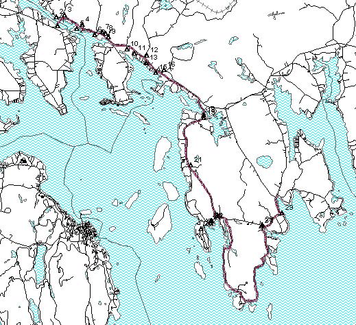
Going left at the Route 186 and Maine Street intersection at mile 15.3 you'll reach the Moore Road that leads to the entrance of the Schoodic portion of Acadia National Park. The Park contains a 6.5-mile loop winding the traveler by unparalleled views of the coastline. The following five paragraphs and map appear in a 1996 National Park Service informational flyer.
"Schoodic Peninsula, the only part of Acadia National Park found on the mainland, boasts granite headlands that bear erosional scars of storm waves and flood tides. Although similar in scenic splendor to portions of Mount Desert Island, the Schoodic coast is a more secluded area. It is about a one-hour drive from the park visitor center to Schoodic Peninsula."
"The park boundary is marked by a sign just before you reach Mosquito Harbor Bridge. Beyond the bridge, Frazer Point Picnic Area, with tables, fire rings, comfort stations and drinking water, offers seacoast views of islands, coves and rocky beaches. Leaving the picnic area, the park road is one-way and parallels the western shore of Schoodic Peninsula to Schoodic Point. There are automobile turnouts for viewing along the way. From these turnouts you can see the Mount Desert profile. Cadillac Mountain is the highest land on the horizon. From each turnout, you may enjoy views of lobster boats, wheeling gulls, and forest-draped islands."
"About two and one half miles from the picnic area, an unmarked trail ascends to the top (440 feet) of Schoodic Head (mile 19.0). This is a narrow gravel road, so please exercise caution when meeting traffic. Although you can drive up the one-mile road, you may choose to walk. On a clear day, from the summit, vistas of the ocean, forest and mountains claim your attention. Returning to the main road, keep right at the intersection past the entrance to the U. S. Naval Station to reach Schoodic Point. This is a two-way section of road. Along this windswept coast, huge granite ledges turn Atlantic waves into lofty geysers and dark colored basaltic dikes intrude between slabs of pink granite."
"After leaving Schoodic Point, bear right and follow the road one-way again-until you reach Blueberry Hill Parking Area (mile 21.4), about one mile beyond Schoodic Point. If you look towards the ocean, Schoodic Island emerges. To your right is Little Moose Island. Behind you and across the road is a steep slope called The Anvil. You can reach the summit of this 180-foot promontory via the trail (mile 22.4) which starts across the road from the parking lot. About two miles from Blueberry Hill Parking Area, the park ends at Wonsqueak Harbor. Two miles beyond the park is the village of Birch Harbor and the intersection to Route 186."
"Although overnight camping is not permitted in the Schoodic section of Acadia National Park, private campgrounds nearby offer camping facilities. For current information, ask a park ranger or write: Chamber of Commerce, Winter Harbor, Maine 04693."
At mile 22.7 you leave the park and re-enter the Town of Gouldsboro in the tiny village of Wonsqueak Harbor. This photogenic village features fishing piers and a shack that used to store rotting fishing bait, now posted as "Schoodic Sushi". The byway follows the shore to Bunkers Harbor at mile 23.3. This is the site of the Bunkers Harbor Research Center, devoted to bridging the gap that exists between scientists, government regulators and the fishing industry. This research center will be open to the public and act as an important center for education and research. As you continue Birch Harbor on the right may appear as a serene harbor at high tide or as an extensive mud flat at low tide. Next you come to the center of Birch Harbor at mile 24.6. The village contains a church and old schoolhouse that now functions as a store, a small retail plaza. Here we rejoin Route 186.
Turn right on Route 186 continue until your reach Prospect Harbor at mile 27.2. This is the end of the second designated portion of the byway. Prospect Harbor is the busiest of Gouldsboro's harbors. Stinson's Seafood Company, a sardine cannery and major employer for the area, is located on the right as you enter the harbor area. Driving along the harbor's edge, you'll notice a variety of fishing boats moored in the harbor. The working lighthouse located across the harbor was commissioned by George Washington and is owned by the Navy. The property is rented out to visiting military personnel throughout the year. You will pass the Gouldsboro town office and the Gouldsboro Women's Club, with views of Prospect Harbor still visible on the right.
Going a little further, Route 195 turns to the right toward Corea, a classic Maine fishing village. Corea Harbor is the site of a local lobster pound. This picturesque village was home to Louise Dickinson Rich, a famous Maine novelist.
Continuing on Route 186, you'll pass US Bells, a well-known bell maker who manufactures bells using old time techniques. The shop gives demonstrations and sells a variety of metal objects that they have manufactured. Route 186 continues through a winding forested corridor. The road crosses a small stream, which empties into Grand Marsh Bay behind West Bay Floral. Further along you will see the shores of the Petit Manan Wildlife Refuge located in Grand Marsh Bay. The road continues by area houses winding the traveler back to Route 1.
Table 1 Summary of Historic Buildings and Sites (#'s Correspond to map that follows)
|
# |
Historic site or structure |
Location |
Historic value |
|
1 |
Old ferry landing remnants |
Hancock side immediate right |
Built in 1926, the ferry barge took people and carriages until "singing bridge" was built. |
|
2 |
Quarry Wharf built of Sullivan�s granite |
West Sullivan left of the bridge |
Serviced area�s granite quarries. By 1830 four major quarry company in Sullivan shipped out of this wharf. |
|
3 |
Sumner House � Sumner Park Town watering trough (stone) Moved to park from stone store. Made by Children Group in 1910. |
After crossing bridge, park is in front of the sumner house |
Names for Dr. Charles Sumner, local physician who donated land for the park in 1948. Contains granite monument honoring local war veterans. |
|
4 |
Sullivan Harbor Park. Surrounded by homes turned into small hotels/boarding houses. Booming business by 1880�s � summer tourists, mining quarry workers needed places to stay. |
Just before Dunbar�s store (Miramac Rd) Sullivan Harbor. |
Monument to Colonel Paul Dudley Sargent who fought under George Washington. |
|
5 |
Dunbar House Edgewater Cabins |
Sullivan Harbor at the end of Miramar road. |
Seasonal restaurant 1900�s Tourist cabins 1930�s |
|
6 |
Stone Store (In 1931 it was rented and used as a curiosity shop antiques) |
Sullivan Harbor Right side of Rt. 1 |
1860 Old Salt Storage House for local fisheries. List on the National Register. |
|
7 |
Simpson House |
Sullivan Harbor Left hand side of Rt. 1 right after Stone Store. |
Sea captain�s house built in 1790. Former location of the Simpson�s store and post office. |
|
8 |
Cascade House (Large red building) |
Left hand side � just before Rt. 200 |
1876 built as Inn, then retail grocery and feed store in 1920�s. |
|
9 |
L.A. Gray ice cream parlor (small red building) |
Left hand side at Mill Pond |
In 1915 used for selling ice cream formerly used as Henry Preble�s ice house, now owned by L.A. Gray. |
|
10 |
Simpson�s Cemetery (miniature replica of 1st. Union Church) |
Right hand side East Sullivan |
First Union Church built 1825 |
|
11 |
Watson�s farm Sea Captain�s house |
Right hand side East Sullivan |
Working saltwater farm that raises beef cattle. |
|
12 |
Hanna Brother�s store and post office |
Right hand side East Sullivan |
Village center � late 1800�s |
|
13 |
Flanders Bay Cabins |
Right hand side East Sullivan on Flanders Bay |
Tourist cabin�s and T-room 1930�s. |
|
14 |
Admiral Byrd Mansion |
Route 183 Tunk Lake |
National Register of Historic Places, but burned 1984 |
|
15 |
John Dority Grange #381 |
Right hand side East Sullivan corner of Old Rt. 1 |
Built 1870 used for local gatherings ever since. |
|
16 |
Farmstead Tea Room |
On right hand side East Sullivan |
Restaurant for travelers and locals. For past 25 years the Barn�s used for Free Art Programs during the summer |
|
17 |
West Gouldsboro Village Town Park |
Intersection of 186 and 186 opposite Maine Kiln Works and Sunset House. |
Park fixtures designed by Eric Soderholtz in the 1930's. |
|
18 |
Gouldsboro Village Library |
Left side on Rt. 186. Near to Eric Soderholtz cottage, also on the National Historic Register. |
Built 1907. National Register of Historic Places. Stone work by Eric Soderholtz. Design by Fred L. Savage. Owned by village improvement society. |
|
19 |
West Gouldsboro Union Church |
Left side on Rt. 186 |
Listed on the National Register. Queen Ann architectural style. |
|
20 |
Archaeological sites - 26 prehistoric sites identified in the area. |
Gouldsboro along coastline |
Prior to European settlement Indian Shell heaps. |
|
21 |
Union Evangelical Church |
South Gouldsboro on left of 186 |
|
|
22 |
Winter Harbor Town Office |
Right onto Main Street into downtown |
Built 1909 as the Town schoolhouse. Last class graduated in 1952. |
|
23 |
Channing Chapel Public library |
Village of Winter Harbor |
Built in 1888 as a Unitarian Church. Bought in 1992 by the Channing Chapel Preservation Society, rented to Town as a library. |
|
24 |
Hammond Hall |
Village of Winter Harbor |
Built 1904, land donated by E.J. Hammond. Maintained by Winter Harbor Historical Society. Location for summer arts performances. |
|
25 |
Winter Harbor Village Business District |
Village of Winter Harbor |
Hanover Building built in 1860. Former tower on Art Gallery used as a lookout for WW II air invasions. |
|
27 |
Birch Harbor Baptist Church |
Birch Harbor Village Intersects w Rt. 186 |
|
|
28 |
School house |
Birch Harbor Village Intersects w Rt 186 |
Currently a private residence |
|
29 |
Stinson�s Seafood |
On right enter Prospect Harbor |
Largest Sardine cannery in the Eastern U.S.. |
|
30 |
Prospect Harbor Light |
Close across the harbor as you drive through |
Built in 1850 and automated in 1951. It now serves as a Navy recreation area. Listed on the National Register |

WHERE ARE WE GOING? A VISION AND GOALS
The Schoodic Scenic Byway is the gateway to Downeast Maine. The byway provides residents and visitors alike with the opportunity to live a unique, "down-east" piece of the American mosaic. Our communities are the home of rugged coastlines, harbors filled with fishing, lobstering and recreational boats, baked bean suppers and independent thinking.
This scenic byway ties together three traditional Maine communities with Acadia National Park�s Schoodic Peninsula. Residents, local businesses and elected-representatives work together to preserve and promote the economy, traditional and innovative land use and a clean, healthy environment throughout the corridor.
Residents of Sullivan, Gouldsboro and Winter Harbor are able to travel safely in their own communities, with better accommodation for driving, walking and bicycling. Visitors have adequate places to leave their cars and recreational vehicles so that they can explore our communities and Acadia National Park by bus, bicycle, boat, and on foot.
The economy is diversified and sustainable with businesses that attracted to our hard working citizens, marine resources and the high quality of life. Much of our workforce continues to be self-employed entrepreneurs. New businesses work with community leaders to strike a balance between the need for visibility and the importance of preserving the beauty that we all need. We enjoy year round tourism, with visitors interested in down-east recreation in snow, flowers, sun and autumn colors.
Our communities continue to support instituting reasonable measures to preserve scenic views and historical and cultural resources and to enhance safety for residents and visitors.
GOAL 1: maintain and enhance the scenic and historical value of the Scenic Byway
Without scenery, without historic landmarks, without the working landscapes of the Schoodic Region, there is no call for a scenic byway. Yet, the experience in other towns suggests that the absence of planning can result in commercial sprawl and a loss of intrinsic resources, eventually denigrating towns to parking and shopping way-stations for people looking for the "real Maine". The objectives listed here are part of a balanced strategy that seeks to protect historic and scenic resources, property rights of land owners and the quality of life that resident hold dear.
Objectives
Inventory scenic and historical locations
Rank priorities for scenic and historic preservation
Identify resources for scenic preservation
Enter written partnership agreements to preserve scenic and historical values
Strategies
Work with community leaders, business leaders and landowners to identify scenic locations
Partner with area Historical Societies to identify areas of historical significance
Examine existing ordinances, identifying strengths as well as gaps and inconsistencies
Work organizations such as the Route 1 Corridor Committee, Schoodic Area Chamber of Commerce, Schoodic Futures, Hancock County Planning Commission, Eastern Maine Development Corporation, Maine Department of Transportation and the Maine Department of Environmental Protection to match resources with needs.
Performance Measures
Completed Inventory of Historic Assets
Additional structures listed on the National Register
Passage of new policies at state and local levels to protect scenic and historic properties
Private and public funds devoted to historic preservation
Additions to accessible scenic overlooks, turnouts and park areas
GOAL 2: provide safe traveling lanes for pedestrians, Bicycles and Motor vehicles
Safety is "number one" in the minds of members of the Corridor Advocacy Group and was repeatedly stressed in public meetings. In order for the Byway program to be considered successful in this region it must increase safety for residents and visitors over the status quo. The status quo does leave room for improvement. Issues noted in public meetings include lack of space for bicycles and pedestrians, tourists attempting to see and photograph scenic vistas without a proper place to stop and sometimes note stopping at all, drivers exceeding posted speed limits, and large vehicles lacking adequate space and obstructing roads. The objectives listed below are only a first attempt at mitigating existing problems many of which will grow worse as tourism continues to increase in the future.
Objectives
Identify locations for bicycle routes
Identify funds for scenic byway improvements
Identify automobile turn-out locations
Identify signing ideas for scenic locations
Identify needed road improvements
Identify parking and traffic ordinances
Increase sensitivity of RV drivers of their impact on communities and fellow travelers.
Strategies
Work with DOT to identify locations for turnouts
Committee prepares mock signs for community evaluation
HCPC prepares regional integration document for bicycle routes
Apply for Federal and State grants for safety and transportation
Provide "staging" or parking areas for RVs to switch to alternative modes of transportation, such as bicycles, towed vehicles or buses.
Performance Measures
Road reconstruction and resurfacing (primarily through six-year planning process)
Shoulder paving and other trail construction for bicyclists and pedestrians
Improved scenic turnouts and park-and-ride facilities along the byway
Placement of safety related signage for traffic calming and visitor information
Reductions in safety reports and accidents relative to daily volume of traffic
GOAL 3: Foster Participation And Community Support For The Scenic Byway
Public participation has been essential to the creation of this corridor management plan and will be equally critical for future protection of the intrinsic values. The Towns of Sullivan, Gouldsboro and Winter Harbor will be active in two ways to support the Scenic Byway. First, they will be active participants in the Corridor Management Committee, the coordinating body that will promote the byway locally, identify national, state and local resources for making improvements and will act to provide information to local planning boards and select boards about how byways can be protected. The Towns will also embark on a multi-year effort to consider and adopt policies that will encourage development that does not diminish the historic and scenic values identified on the byway. Details about this process are described in the section on Protection Techniques. The towns will be assisted in there efforts by the Route 1 Corridor Committee, the Regional Transportation Advisory Committee and several partners at the state level.
Objectives
Define and implement an ongoing Community Participation Program
Use the print and broadcast media to keep the public informed
Provide educational open forums, meetings and workshops
Pursue new protection techniques to encourage preservation of historic and scenic resources.
Pass the Corridor Management Plan in all three towns at annual meetings
Strategies
Build expertise within the Corridor Advocacy Group
Byway Committee and HCPC provide draft press releases
Build and display a Scenic Byway informational signboard
Invite guest speakers to open forums and meetings
Invite community leaders, businesses and members to open forums and meetings
Arrange meetings with DOT, SBC and Hancock County Planning Commission and other professional groups to make presentations at the workshops
Performance Measures
Passage of the Corridor management plan at public meetings
Attendance at public meetings, public hearings and other events
Publications and other media presentations about the byway
Grant applications completed and successful
Commitments of local support for completion of byway objectives
GOAL 4: Promote Education On The Need For Resource Protection And Preservation
There are many unexploited opportunities for education of visitors about the scenic, natural, historical and cultural resources of this region. One humorous definition of education is "the process of learning what you didn�t know you didn�t know." Of the five goals in this plan, education should be considered the most amenable to new ideas and methods for implementation. As such, the objectives set forth in this plan are suggestive rather than comprehensive.
Objectives
Identify historical landmarks and create interpretive signage
Identify and promote off-byway side trips
Identify natural resources and create interpretive signage emphasizing the local economy
Strategies
Provide educational open forums, meetings and workshops
Provide information at scenic turnouts on scenic, historic and cultural assets
Provide travelers maps with insets for off-byway sites, such as Tunk Lake, Corea and West Gouldsboro.
Performance Measures
Greater awareness and appreciation of historic and scenic landmarks
Use of byway side trips, particularly at times when primary routes are congested
Use of educational materials on local natural resources by residents and visitors
Reductions in littering, damage to wildlife habitat, damage to archeological sites and other harm to the local natural and cultural resources.
GOAL 5: Support Year-Round Economic Growth AND Seasonal Tourism
The economies of Sullivan, Gouldsboro and Winter Harbor, like much of the state, are a mix of natural resource based activity, the Schoodic Navy Base that recently scheduled to close, summer residents who own much of the coastal property and tourism. Tourism works in this region in part because of the local economic activities, such as lobstering, clamming, blueberry farming and timber growth, are a fascinating lesson for visitors from the south and west. Local agricultural and marine activities work in part due to the boost that local markets get from the influx of summer people and tourists. The balance, however, is difficult to maintain. The heavy influx of tourists in July and August strain local capacity for services and boost real estate prices beyond the means of many residents. The equally dramatic decline in tourism in the off season leaves many residents without jobs.
One means of creating a more sustainable tourism sector in this region is to adopt measures which encourage more visitors during the shoulder season, particularly early summer and early to late autumn. Other means include spreading tourists out of the more congested areas into less frequented locations and identifying ways to reduce the number of motor vehicles in areas have room for additional people but not for additional cars. The scenic byway program can promote sustainable tourism through marketing the off-seasons, encouraging visitors to see the full range of working and recreational landscapes in the region and encouraging use of transit options like buses and boats. The byway may be used to promote the region for enterprises that value the natural and historic values of the region, such as education, research and development facilities, marine resources businesses and retirement communities.
Objectives
Identify ways that scenic byway improvements can support an extended tourist "shoulder" season
Develop informational materials for local investors for business start-ups � emphasize quality of the work forces and quality of life.
Strategies
Develop informational materials for tourists emphasizing off-season activities such as autumn colors, hunting, fishing and cultural activities.
Work with State Legislators, economic and tourism groups
Work with the Department of Economic and Community Development, Eastern Maine Development Corporation, Hancock County Planning Commission, Schoodic Area Chamber of Commerce, Schoodic Futures and other organizations
Coordinate Scenic Byways projects with Strategic Passenger Transportation Plan
Performance Measures
Increases in tourism during the shoulder and off-seasons
Economic diversification, measured in creation of employment in a broad range of industry and occupation categories.
Increases in year round employment in the region, particularly jobs paying livable wages
WHO IS COMING WITH US? BYWAY PARTNERSHIPS
Members of the Schoodic Corridor Advocacy Group started over four years ago in the designation process. This grass routes team has included elected officials, local businesses and residents who are working to improve the transportation infrastructure, protect local scenic and historic assets and strengthen the local economic base.
Table 2 Corridor Advocacy Group Membership
|
Town of Sullivan |
|
|
Name |
Affiliation |
|
Barbara Shanahan, Committee Chair |
Resident and Business Owner, Route 1 Corridor Committee |
|
Frank Dedmon |
Select Board |
|
John J. Somers |
Select Board |
|
William E. Martin |
Resident and Business Owner |
|
Leslie Harlow |
Resident and Business Owner |
|
Town of Gouldsboro |
|
|
Name |
Affiliation |
|
Stanley Torrey |
Select Board, RTAC-2 Member |
|
Dick Bennet |
Resident, Committee Historian |
|
Town of Winter Harbor |
|
|
Name |
Affiliation |
|
Peter Drinkwater, Committee Secretary |
Planning Board, Business Owner, Chamber of Commerce, Schoodic Area Futures |
|
Wesley S. Hills |
Select Board |
|
Regional, State and National Representatives |
|
|
Name |
Affiliation |
|
Jim Fisher |
Planner, Hancock County Planning Commission |
|
Deanne Van Dusen |
Byway Coordinator, Maine Department of Transportation |
|
Mike Hoover |
RTAC Coordinator, Maine Department of Transportation |
|
Bruce Mattson |
Division Engineer, Maine Department of Transportation |
|
Len Bobinchock |
National Park Service, Acadia National Park |
|
Bill Weidner |
National Park Service, Acadia National Park |
Community Participation Program
The Scenic Byway Program depends upon significant, grass-routes participation. In its design, it is a local program with the opportunity for national and state recognition and support. Without local leadership the corridor management plan cannot be written, the status of scenic byway will not be granted, and Federal and State grants will not be forthcoming. This section documents how Sullivan, Gouldsboro and Winter Harbor worked together to create a corridor management plan.
The Schoodic Byway Community Participation Program was designed to:
The Scenic Byway journey has taken more than two years to date. Progress has been slow, but steady, and has demanded varying levels of commitment from community leaders and citizens. Some participants have attended dozens of meetings, arranged mailing lists and written sections of the plan while many have limited their participation to attending public meetings or communicating through acquaintances on the CAG.
In order to assure that representation was adequate, the CAG assembled a list of stakeholders in the scenic byway. The list below includes groups and individuals that have a stake in the corridor�s designation
Table 3 Stakeholders and Partners
|
Adjacent property owners |
|
More than two hundred households, businesses and institutions. |
|
|
|
Local Government: Sullivan, Gouldsboro, and Winter Harbor |
|
Select Boards |
|
Code Enforcement Officers |
|
|
|
State and Local Service Organizations |
|
Bicycle Coalition of Maine |
|
Garden Clubs |
|
Historical Societies (Sullivan, Gouldsboro, Winter Harbor) |
|
Route 1 Corridor Committee |
|
Schoodic Area Chamber of Commerce |
|
Schoodic Futures |
|
Women�s Clubs |
|
State Government |
|
Maine Department of Transportation |
|
State Planning Office |
|
Maine Department of Environmental Protection |
|
|
|
National Government |
|
National Park Service � Acadia National Park |
|
US Department of Transportation Federal Highway Administration (FHWA) |
|
|
|
Utilities |
|
Bangor Hydro Electric |
|
Bell Atlantic |
|
Frontier Vision (Cable TV) |
Public Relations / Marketing in the Communities
The Byway effort has been going for over four years, first through the exploratory phase, the eligibility application and the most recent push for designation. The following table records events of the past seven months and illustrates the level of effort expended by the Corridor Advocacy Group to work with local residents and other interest groups in crafting a Corridor Management Plan.
In order to write this plan a multimedia strategy was employed. Residents living along the byway, both summer and year round received invitations to the public meetings. Two one-hour radio broadcasts were delivered and several articles were published in the leading local and regional newspapers. The Hancock County Planning Commission published several letters in their newsletter and placed information on their web site. Public presentations were delivered to local planning boards and select boards. Meeting notices were published in local newspapers as well.
Two public meetings were held to provide greater depth of information about the byway and to receive public input. All of the Corridor Advocacy Group Meetings were publicized and open to the public.
Table 4 Summary of Public Meetings and Events During 1999
|
Date |
Venue |
Activity |
|
3/10 |
HCPC Meeting |
Plan CMP Strategy |
|
3/24 |
First CAG Meeting, Sullivan Town Offices |
Begin identifying goals and objectives |
|
4/6 |
CAG Meeting, Sullivan Town Offices |
Goals and objectives |
|
4/21 |
CAG Meeting, Sullivan Town Offices |
Goals and objectives |
|
5/5 |
CAG Meeting, Sullivan Town Offices |
Dean Van Dusen Presentation, Goals and objectives |
|
5/20 |
CAG Meeting, Sullivan Town Offices |
Goals and objectives |
|
6/2 |
CAG Meeting, Sullivan Town Offices |
CPP, Kiosk, Background Conditions |
|
6/15 |
CAG Meeting, Sullivan Town Offices |
CPP, Partnerships and Agreements, Kiosk, Background Conditions |
|
6/18 |
Winter Harbor Election |
Kiosk displayed, Warrant for Scenic Byway not included in vote. Reason unknown. |
|
6/21 |
Winter Harbor Town Meeting |
Kiosk displayed |
|
6/22 |
Gouldsboro Election |
Kiosk displayed, Town Meeting authorized $1,000 support for Scenic Byway Planning |
|
6/28 |
Sullivan Town Election |
Kiosk displayed, Town Meeting authorized $1,000 support for Scenic Byway Planning |
|
7/7 |
CAG Meeting, Sullivan Town Offices |
CPP, Partnerships and Agreements |
|
7/7 |
Sullivan Planning Board |
Met with board, described scenic byway program and their role. |
|
7/9 |
Schoodic Futures |
Attended meeting, presented SB1 poster, answered questions |
|
8/4 |
CAG Meeting, Sullivan Town Offices |
Partnerships and Agreements, CMC, Background Conditions Analysis |
|
8/7 |
Sullivan Days and Opening of Hancock Sullivan Bridge |
Kiosk displayed at pancake breakfast and in Town Park |
|
8/26 |
Printing and Mailing 300 Meeting Notices |
Notice to adjacent property owners of Scenic Byway public meeting. |
|
9/1 |
CAG Meeting, Sullivan Town Offices |
Planning for public meetings, review of property tax maps, discussion of CMC. |
|
9/7 |
Gouldsboro Planning Board |
Discussion of designation and implementation phases, emphasizing the role of the planning board. |
|
9/8 |
Public Meeting � Prospect Harbor |
Overview of Byway program, presentation from ANP. Visioning exercise. |
|
9/9 |
Public Meeting � Sullivan |
Overview of Byway program, presentation from Sullivan Historical Society and ANP. Visioning exercise. |
|
9/22 |
CAG Meeting, Sullivan Town Offices |
Review of public meetings, land use planning, marketing |
|
9/24 |
Radio Broadcast about Scenic Byways |
Jim Fisher, Dean Van Dusen, Frank Dedmon and others interviewed on Talk of the Town, WERU 10:00 am to 11:00 am. |
|
10/06 |
Sullivan Planning Board |
Presentation of key points from CMP, plan for submission, review and recommendations. |
|
10/07 |
Gouldsboro Select Board |
Presentation of key points from CMP, plan for submission, review and recommendations |
|
10/08 |
CAG Meeting |
Proposed Action Plan |
|
10/13 |
Sullivan Select Board |
Presentation of Draft Corridor Management Plan |
|
10/19 |
Gouldsboro Planning Board |
Presentation of Draft Corridor Management Plan |
|
10/22 |
Scenic Byway Planning Meeting |
Met with byway planners in Augusta, MDOT |
|
10/25 |
CAG Meeting |
Review of draft CMP |
|
11/08 |
CAG Meeting |
Review of draft CMP |
|
12/17 |
CAG Meeting |
Revise CMP Draft |
ONGOING MANAGEMENT AND ORGANIZATION
One of the many challenges facing Scenic Byways is their tendency to self-destruct. Self-destruction comes in several forms, but most common are increasing demands for services spurring unattractive commercial growth and changing community values leading to loss of public access. In the case of the Schoodic Byway these trends are already evident and the outcome likely to be unplanned and unsustainable if communities choose a passive role. Strip development has been on a long, steady march up coastal Route 1.
This management structure is recommended to assure the implementation of the corridor management planning process. The plan and management roles are not permanent or irrevocable. They are a first step that will require evaluation and adjustment.
THE CORRIDOR MANAGEMENT COMMITTEE
Affiliations and Responsibilities
The Corridor Management Committee (CMC) will be responsible for implementation and adaptation of the Corridor Management Plan. The CMC must coordinate the many local, regional, state and national organizations that will be involved. The CMP is a living document and will require continual review and revision. Accordingly, the CMC will be responsible for involving local organizations and residents in the process of continual evaluation.
In order for physical enhancements to implemented, the CMC will need to coordinate local, state and federal resources, work with the Maine Department of Transportation and other State Agencies to prepare designs and contract construction firms. The Department of Transportation, the Hancock County Planning Commission and other organizations will assist in this process.
The CMC will also be responsible for monitoring progress on improvement project and reporting progress back to the local select boards and to the Maine Department of Transportation. The CMC will be a recognized Corridor Committee and will report to the Regional Transportation Advisory Committee for Region 2 (RTAC), Hancock and Washington County, every 2 months on the progress of Byway planning and implementation. Employees of the regional office of the Department of Transportation and the Hancock County Planning Commission will assist them in this task. The CMC will prepare annual reports to be presented to the RTAC, MDOT and Federal Highway Administration.
Finally, the CMC will be responsible for keeping the public informed and involved in the Scenic Byway. They will be assisted in this process by local news media, community leaders and the Hancock County Planning Commission.
Table 5 Corridor Management Committee - Members for 2000-2001
|
Town of Sullivan |
|
|
Name |
Affiliation |
|
Frank Dedmon |
Select Board |
|
Peter Shanahan |
Planning Board |
|
Jack Riley |
Code Enforcement Officer |
|
Barbara Shanahan |
Business Owner Route 1 Corridor Committee |
|
Leslie Harlow |
Business Owner |
|
Town of Gouldsboro |
|
|
Name |
Affiliation |
|
Stanley Torrey |
Select Board RTAC-2 Member |
|
TBA |
Planning Board |
|
Dick Bennet |
Resident |
|
Town of Winter Harbor |
|
|
Name |
Affiliation |
|
Wesley S. Hills |
Select Board |
|
Peter Drinkwater |
Planning Board, Business Owner, Chamber of Commerce, Schoodic Area Futures |
|
Roger Barto |
Town Manager |
|
Regional, State and National Representatives |
|
|
Name |
Affiliation |
|
Jim Fisher |
Planner, Hancock County Planning Commission |
|
Mike Hoover |
RTAC Coordinator, Maine Department of Transportation |
|
Bruce Mattson |
Division Engineer, Maine Department of Transportation |
|
Bill Weidner |
National Park Service, Acadia National Park |
The communities on the Schoodic Byway are and will remain the leaders in Scenic Byway management. They will retain all of their current authority over land use along the corridor, and will bear the concomitant responsibilities. Each of the towns will divide responsibility between their elected Selectmen and appointed planning boards.
The boards of selectmen will to provide local leadership in the implementation of the corridor management plan.
The boards of selectmen will review proposals for improvements to the byway. While the current funding formula does not require a local match, the boards of selectmen may make recommendations for local contributions for byway development. These recommendations will be presented at annual town meetings.
The Towns of Sullivan, Gouldsboro and Winter Harbor encourage residents to maintain their property through annual bulky waste collections in which most forms of bulky debris and waste are collected at no charge.
The local planning boards will play a primary role in the implementation of the corridor management plan. The planning board will routinely review the plan, indicating any inconsistencies with the existing comprehensive plan, zoning or ordinances. This CMP and subsequent revisions will be adopted within the Towns Comprehensive Plan at annual town meetings.
The planning board will assist in preparation of grant proposals for byway improvements.
One member or designee of each planning board should serve on the corridor management Committee and act as liaisons to their boards.
The planning boards will assist in interpreting the CMP and related ordinances for persons seeking to change activities located on or near the byway.
THE ROLE OF PUBLIC AGENCIES / INSTITUTIONS
Federal, state and county organizations will support the Scenic Byway through infrastructure development, maintenance, technical assistance and administrative support.
US Department of Interior � National Park Service (NPS)
The Schoodic Peninsula portion of Acadia National Park will remain under the management of the National Park Service. Their goals for this portion of the byway are compatible with the Corridor Management plan.
Federal Highway Administration (FHWA)
The FHWA manages the National Scenic Byway Program. They will continue to provide standards and technical support for creation and maintenance of scenic byways, marketing assistance for byways and financial support opportunities for approved byway enhancements.
Department of Transportation (MDOT)
The Maine Department of Transportation will work with town and county government to support the byway with improvements that are consistent with the corridor management plan and consistent with town preferences. MDOT will provide technical assistance to Town governments on matters such as road construction standards, safety, parking facilities and alternative modes. MDOT will assist in writing federal grant applications for byway improvements and will seek to provide state matching funds whenever possible.
State Planning Office (SPO)
The State Planning Office will provide financial and technical support for land-use and transportation planning along the byway corridor. SPO will assist the towns in determining whether specific development proposals are consistent with the Town comprehensive plans and with byway goals and objectives.
Department of Environmental Protection (DEP)
The Department of Environmental Protection will provide towns with technical support to determine appropriate design of byway improvements to minimize negative environmental impacts. DEP will provide financial assistance, whenever possible, to towns for mitigation of existing environmental problems along the byway.
Maine Department of Public Safety
The Maine Department of Public Safety will provide back-up law enforcement services along the byway to control illegal activities such as speeding, operating under the influence and reckless operation. The Maine Department of Public Safety will provide technical assistance to the towns to determine traffic calming and driver education measures to improve safety for persons traveling and living along the byway. State Police service for Hancock County is administered through the East Machias headquarters. Contact: State Police Troop J Headquarters, P.O. Box 250, East Machias, Maine 04976, Phone: (207) 255-6125, Fax: (207) 255-6113.
Maine Historical Preservation Commission
The Historical Preservation Commission is represented on the State Scenic Byways board and will play an active role in educating the local historical societies and providing channels for financial support of inventory, education and preservation activities.
Hancock County Planning Commission (HCPC)
The Hancock County Planning Commission will act as a liaison between the towns and state government. The HCPC will provide technical assistance in transportation, land use, environmental and other planning. The HCPC will assist towns in submitting and implementing federal and state byway improvement grants.
Office of the County Sheriff
The County Sheriff will provide back-up law enforcement services along the byway to control illegal activities such as speeding, operating under the influence and reckless operation. The Sheriff will work with the State Police, local police and constables and town leaders to determine how to reduce incidence of speeding, operating under the influence, reckless operation and other violations. The County Sheriff's office provides dispatch services and call sharing in which the county is divided into slots serviced by State and County law enforcement at different times. The Hancock County Sheriff's Office is located in Ellsworth, Maine 04605, phone: 667-7576 or 667-1404.
Utilities - Bangor Hydroelectric Corporation, Bell Atlantic, Frontier Vision
The Utilities shall inform towns of significant changes in distribution networks, including location of poles, wires, transformers and other structures and work with CMC and planning boards to avoid construction within the identified scenic vistas. They will collaborate with the towns to identify opportunities for relocating infrastructure away from scenic areas, including future underground cabling through downtown areas.
Schoodic Area Chamber of Commerce
Assist in marketing the region and encouraging local businesses to expand in ways that do not detract from the scenic character of the region.
THE ROLE OF COMMUNITY ORGANIZATIONS
PROTECTION TECHNIQUES FOR LONG-TERM MANAGEMENT
Zoning, Reviews, Incentives and Voluntary Agreements
Many techniques exist for protecting Scenic Byways, ranging from top-down control, generally exerted by a governmental body, to market oriented methods relying on economic incentives and voluntary agreements. These regulations, incentives and agreements are summarize by town, below, and compared in a summary table.
On the "control" end these three byway towns employ a mix of Cartesian land use zoning, location specific ordinances and land use controls. Winter Harbor has adopted land use zoning which applies to the Route 186 corridor and prescribes limitation to development based on location. All three towns have land use and building ordinances which govern future development.
A less strident category of development controls, generally referred to as "reviews" are employed to varying extents in all three towns. Reviews are intended to measure impacts of a proposed project on the surrounding economy, environment, social networks, transportation and so on. These include site reviews, environmental impact reviews, design reviews and access management reviews. All three towns, and thus the entire proposed byway, are under the authority of planning boards and code enforcement officers. Proposals for construction, such as new buildings, significant changes in the landscape, land use, and drainage, must be presented to the planning boards to assure that the changes are consistent with local plans, ordinances and state laws.
Economic measures to protect a scenic view include fees and penalties such as developer fees and retroactive taxation when land is taken out of an easement. Economic measures also include incentives for resources protection such as purchase of development rights, tax abatements for easements, development bonuses, and purchase of property. Here again we find all three towns use these measures in a variety of situations. There are presently several land trusts active in the Schoodic area. All three towns own or have acquired land for public access to the water, open space and historic preservation.
A referendum passed in the November, 1999 general election opens the door for communities to use property tax policy to encourage preservation of historic and scenic resources. The towns will need to evaluate the costs and benefits of this new option in coming years.
The fourth avenue for protecting scenic byways is education and voluntary participation. Many of the adjacent land owners on the Schoodic Byway have signed voluntary partnerships with the Corridor Advocacy Group stating their firm desire to preserve and enhance their properties. The action plan calls for ongoing efforts to educate property owners about methods for maintaining historic and scenic property, and to provide tools for long term preservation. Education and voluntary action are not alternatives to the other strategies, but are required components of all strategies.
Sullivan, Gouldsboro and Winter Harbor have adopted a variety of measures for preserving their landscape and quality of life. All three towns employ code enforcement officers and other inspectors to implement town policies. All three towns have planning boards that help to set policy and rule on construction permits, site designs and other day to day growth management. In addition to local policies, described below, the byway passing through all three towns is significantly affected by state and federal regulations for development in shoreland as well as other areas that are environmentally sensitive. The three towns regulate new construction through their planning boards, boards of appeal, town managers and code enforcement officers. All three towns also pay close attention to their waterfronts with appointed Harbor Committees to set policies such as permissible harbor uses, moorings, and use of boat ramps. Each town designates a Harbormaster who oversees day to day operations, prevents littering and other misuse of the harbor facilities.
Moving forward, all three towns are emphasizing the importance of providing education to developers about the long-term importance of maintaining the current "look and feel" of the communities and providing economic incentives to avoid loss of critical natural and cultural assets. The Schoodic Loop portion of the byway is under the authority of the National Park Service and has been designated as a low impact area.
This section explains measures already in place to support the scenic byways designation and assesses their effectiveness. The focus here is on municipal protection measures. These include comprehensive plans, land use ordinances and other regulations or restrictions. This is done on a town-by-town basis.
Comprehensive Plan
Voters adopted the Sullivan Comprehensive Plan in 1993. The plan was deemed consistent with the requirements of the Growth Management Act by the state. Towns with consistent comprehensive plans are eligible for grants to implement the recommendations of their plans. Sullivan used its implementation funds to formulate an economic development strategy and draft land use ordinances. Several ordinances were in place prior to the plan and others are still under consideration.
The Sullivan Comprehensive Plan addresses several issues related to the preliminary goals adopted for the Route 1/186 corridor. It has a thorough inventory of scenic views from public ways. It quotes from an earlier inventory by Friends of Taunton Bay, a volunteer group interested the conservation of bay resources: there are "eight islands punctuating the view from many points. To the east over the treetops, Schoodic Mountain is a constant presence, as are the Mount Desert Island (MDI) hills across Frenchman Bay to the south." These views are clearly one of the essential attributes of Route 1. The plan states that "(t) he spectacular scenic views need to be protected and treated as the important resource that they are."
The plan also addresses historical resources. The Maine Historic Preservation Commission (MHPC) has not conducted an inventory of historical resources in Sullivan. The plan recommends that this be done. Presently, only one building in town is on the National Register of Historic Places, the Granite Store on Route 1. Other buildings are probably eligible for nomination.
Since listing on the National Register offers considerable protection to sites that may be affected by actions involving federal funds, it is an effective protective measure. For example, if federal highway funds were to be used for a roadway widening, other alternatives would have to be considered before the store property could be affected. Listing, however, does not offer protection against actions by owners.
The Transportation section of the plan addresses some of the safety concerns. The plan calls Route 1 "Sullivan�s economic lifeblood." Goals include discouraging "the widening of Route 1 while requiring adequate setbacks along Route 1" and minimizing the occurrence of strip development "by restricting major commercial development to limited areas."
The plan also addresses the resource protection and year-round economic growth goals. Polices include "(t)o make Sullivan inviting to those who pass through and to promote opportunities which encourage travelers to stop, shop, and visit the town," and to "allow marine related commercial development in the waterfront area...that ... is compatible with the environmental, cultural, historical and recreational important of Frenchman Bay."
Ordinances
While Sullivan does not have town-wide zoning, there are a number of ordinances in place that help to protect the scenic byway.
Table 6 Sullivan Ordinances and Regulations
|
Shoreland Zoning |
Much of the byway and most of the very scenic portions are very close to shore. The shoreland-zoning ordinance primarily protects areas within 250 feet of the shore. This ordinance meets state requirements. |
|
Building Codes |
The building codes ordinance sets forth requirements for attaining building permits and provides the planning board with the opportunity to review the site plan for possible violations of shoreland zoning, etc. The building inspector can require landscaping in order to prevent environmental degradation and prevent loss of value in neighboring real estate. |
|
Subdivision |
The subdivision ordinance is not very specific but requires special permitting when properties are subdivided into multiple smaller lots. The comprehensive plan has a list of specific recommendations for subdivision ordinance revisions that would increase its ability to protect scenic and natural resources. |
|
Recreational Vehicles, Campgrounds and Mobile Home Parks |
The town also has recreational vehicle, campground and mobile home park ordinance. It sets standards for road setbacks and access, parking and requires a vegetative buffer strip along any town right-of-way. These standards help minimize the traffic impacts of such development. |
|
Parking and Traffic Control |
Sullivan has a parking and traffic control ordinance. It authorizes the selectmen to designate and mark parking spaces along any street in town. It also prohibits parking in locations such as sidewalks, cross walks, school zones and within ten feet of an intersection. The ordinance also restricts excessive vehicular noise. |
|
Signage |
Sullivan has a sign ordinance to "promote and protect the public health, welfare and safety by regulating outdoor advertising signs and outdoor sighs of all types." One of the state objectives of the sign ordinance is to "preserve the scenic and natural beauty of the town." |
|
Junkyards and Automobile Graveyards |
The Ordinance regulating the establishment/operation of junk yards/automobile grave yards and the storage/disposal of garbage and junk was adopted in 1995 to upgrade the appearance of the community and protect property values. Limitations are placed on the types of materials stored and the length of time that they may be stored without specific permits from the town. |
|
Other |
Sullivan has adopted several other ordinances that support maintaining an attractive and healthy environment. Several sections of scenic overlooks are partially located within the floodplain, also discouraging development. |
Other Protective Measures
Large portions of Route 1 are bordered by ledge and poor soils limiting the amount of construction that can take place. Some parcels are also protected by conservation easements. Several sections along Taunton Bay, Long Cove and Flanders Bay are either too close to mean high tide or are configured in lots that are too small to be developed. A large significant parcel in north Sullivan is now "Public Land" and is reserved for public recreational use, including camping, hiking and kayaking. While this area is a few miles off of the byway, it is a good addition to the visitors itinerary and will remain protected into the foreseeable future.
Analysis
The comprehensive plan notes that current protective measures may be insufficient to manage sprawl and preserve scenic views and natural resources over the long run. This means that the immediate focus of protection efforts should be on voluntary measures and incentives to landowners. Measures can involve conservation easements and the listing of sites in the National Register of Historic Places.
Comprehensive Plan
Gouldsboro�s comprehensive plan was adopted in 1993 and is consistent with the requirements of the Growth Management Act. The plan voices concerns about the detrimental effects of commercial strip development on Route 1 and residential development along Route 186. The plan�s recommendations include enacting revisions to the subdivision ordinance that would normally require residential lots to front on interior roads serving the development rather than on an existing road.
The plan also recommends that town land use ordinances include adequate off-street parking standards for multifamily and non-residential uses such as stores or a manufacturing operation. This would help minimize traffic problems that may result from parking along a roadway. To mitigate off-site traffic impacts from major development, the plan recommends that land use ordinances be revised to state explicitly that the planning board may require developers to prepare traffic impact statements.
The plan notes that Gouldsboro has four areas identified the State Natural Heritage Program, two that are registered by the Critical Areas Program. "Critical areas are defined as naturally occurring phenomenon of statewide significance which, because of their uniqueness, rarity or other critical factors, are deemed important enough to merit special planning and management consideration." (p. I.3) The plan calls for stronger protection measures for these areas.
The section on Historic and Archaeological Resources notes that the the Maine Historic Preservation Commission has identified 26 prehistoric sites in Gouldsboro. Most of these are from coastal native-American settlement prior to the arrival of Europeans.
The plan identifies two structures on Route 186 that are listed on the National Register of Historic Places. These are the West Gouldsboro Union Church and the West Gouldsboro Village Library. Another privately owned property has been determined eligible for listing, and more are expected to be eligible. The plan recommends that the town encourage private groups to undertake a comprehensive survey of Gouldsboro�s above ground resources to determine which structures may be eligible for listing in the National Register of Historic Places.
To avoid strip development on Route 1, the plan recommends that only selected nodes or intersections be zoned commercial. The zoning standards would include minimum depth to width ratios so that long, narrow lots would be avoided. To minimize visual clutter, the plan calls for commercial sign standards.
The plan has several other recommendations that support the scenic byway designation. These include the preservation of scenic views and the development of bicycle paths along Route 186. It also encourages the donation of conservation easements to land trusts to protect valuable natural areas
Land Use Ordinances
The planning board has drafted a town-wide zoning ordinance that has not, as yet, been submitted to town meeting vote. The planning board also undertook major revisions to the subdivision ordinance, which were not adopted at town meeting. There are, however, several protective measures in the current subdivision ordinance.
Table 7 Gouldsboro Ordinances and Regulations
|
Subdivision Review |
The existing subdivision review standards require that subdivisions shall not cause "unreasonable highway or public road congestion." They also give the planning board the right to require the developer to prepare an assessment of the subdivision�s impacts on visual character and scenic and natural beauty. Assessments of impacts on historical and archaeological sites can also be required. |
|
Land Use Ordinance |
Gouldsboro also has a general land use ordinance. While it does not regulate the location of uses, it does require setbacks from roads and side lot lines. It requires a building permit for new structures and major expansions of existing structures. It also requires driveway permits for new entrances onto town ways. |
|
Floodplain |
The Flood Plain Ordinance requires that Flood Hazard Development Permits be obtained before construction or placement of homes can occur within a floodplain. This initiates a review of construction plans, septic systems and other potentially vulnerable infrastructure. Some sections of the byway are adjacent to flood areas. |
|
Standards for Communications Towers |
There are general standards for communications towers. These include a provision that the minimum setback for all towers from lot lines and habitable structures is equal to its height. The permit process requires confirmation that the tower meets appropriate wind and structural load standards. |
3. Other Protective Measures
Land constraints somewhat limit the development potential of Routes 1 and 186 in Gouldsboro. According to data presented in the comprehensive plan, about 56 percent of the soils in town have a "very low" potential for low-density urban development and another 20 percent have a "low" potential. The scenic byway has two segments in Gouldsboro. The Route 1 to Jones Cove section passes through the northwestern section of the Town. Several of the scenic parcels in this section are built quite close to the water with much of the remaining land protected by shoreland zoning. Two important historic buildings in the western portion of Route 186 are also likely to remain as they are.
The second Gouldsboro section of the byway comes at the end, passing through small villages like Birch Harbor and Prospect Harbor. Most of the adjacent land in this segment is enrolled in a Tree Growth Easement program (see map that follows). Property taxes are significantly reduced as long as this land is managed with a forestry management plan. Developing this land in the future would require payment of back-taxes and penalties. Additional parcels in this area may be eligible for tree growth and other land conservation easements. In addition to tree growth and shoreland zoning some of the view-side parcels are located within the 100 year flood plain and subject to Gouldsboro's flood plain ordinance.
Comprehensive Plan
The Winter Harbor comprehensive plan was enacted in 1994. The plan supports many concepts that connect with scenic byway designation. It stresses the importance of preserving the historic character of the town. It also states that the lack of major commercial development and the compactness of the village area are important components of the town�s scenic character. The plan also mentions the Schoodic Loop Road in Acadia National Park, which it describes as having "some of the most beautiful views in Maine."
The recommendations complement the scenic byway designation process. Route 186 is primarily designated as a "rural" portion of town. Per the requirements of the Growth Management Act, towns generally designate rural areas, where only limited, low-density growth will occur. This is compatible with retaining the scenic attributes of Route 186. The only portions of the road not designated as rural are areas that already have substantial commercial or residential development.
The plan also calls for preserving historic buildings and sites. These buildings are part of the scenic character of Route 186. The plan mentions the views from afar of the church steeples and white clapboard buildings. The plan thus appears to offer strong support for the concept of scenic byways designation.
Elements of the plan are presently not consistent with requirements of Maine�s Growth Management Act. Only when these elements are amended the town becomes eligible for matching grant funds from the state of Maine to implement the plan�s recommendations. Impacts of the planned closure of the Winter Harbor Navy Base has renewed interest in town in amending the plan so that Winter Harbor could proceed with implementation.
Ordinances
Winter Harbor has town both shoreland and town-wide zoning. They also have several related ordinances that help to protect the byway. The Winter Harbor Zoning Map appears below. Zoning reinforces the current pattern of development. The non-residential development is encouraged in the New England style village center and much of the byway outside of the village center is set aside for rural and limited residential development.
Table 8 Winter Harbor Ordinances and Regulations
|
Shoreland Zoning |
The shoreland standards are consistent with those required by the Maine Department of Environmental Protection. They include restrictions on timber harvesting, erosion and sedimentation standards and measures to protect highly fragile areas. These standards are important since terms they protect shoreland areas from intense or environmentally sensitive development. Since shoreland areas are one of the key components of the scenic character of Route 1/186, these standards support the scenic byways designation. |
|
Town-wide Zoning |
The town-wide standards apply to those portions of town not subject to shoreland zoning (i.e., beyond 250 feet of most water bodies and 75 feet of wetlands). Route 186 is mostly in the Rural District, which has a one acre minimum lot size and a 25 foot structure setback from the center of the roadway. There are more stringent setbacks (250 feet) for commercial and industrial uses have more than 2,500 square feet of gross floor area and/o employing more than six full-time employees. In such cases, all land between the facility and the public right-of-way must be "appropriately landscaped." |
|
Subdivision |
Winter Harbor has a subdivision ordinance, which sets standards for street construction and public open space. Subdivisions are also subject to the review criteria under the state subdivision law (30-A MRSA 44040). These criteria include avoiding unreasonable and unsafe traffic conditions and protecting aesthetic, cultural and natural values. These measures help assure that any subdivisions will not detract from the scenic character of Route 186. |
|
Building Code, Flood Hazard, Town Pier, Harbor |
The town also has a building code, flood hazard ordinance and town pier and harbor ordinance, which provide the planning board and coded enforcement officer with leverage over future development. |
|
Signage |
Winter Harbor adopted a stringent Sign Ordinance in 1986 that exceeds state requirements in restricting commercial advertising and other signs. This ordinance was enacted in part for "Preserving, enhancing and protecting the natural scenic beauty and other aesthetic features of the Town." |
|
Junkyards and Nuisances |
The Ordinance for Junkyards and Nuisances was written to encourage property owners to keep their land free for debris and to require permits for storage of debris for extended periods. This ordinance is one of several that the Winter Harbor Planning Board will be reviewing in the next year. |
Other Protective Measures
Most of the byway within Winter Harbor lies on Acadia National Park land and is therefor well protected. Some sections along Route 186 are within the village and though developed lend the atmosphere of a small coastal New England Village. Much of the remaining land has been developed in very low density rural and residential uses with wooded buffers. Several sections of scenic overlooks are partially located within the floodplain, also discouraging development.
Analysis
Winter Harbor has taken several steps toward protecting the Scenic Byway corridor, particularly in their efforts to encourage maintaining the traditional village center, shoreland zoning and their sign ordinance. Much of the byway is in National Park Land. Route 186 from Winter Harbor to Birch Harbor is not part of the designated byway. However, persons wishing to reach the designated byway, particularly persons on bicycles who want to complete the Acadia National Park Schoodic Loop, are confronted with conditions that deserve future attention. The roadway is in poor condition and needs to be significantly rebuilt. The Winter Harbor Planning Board is currently initiating a review of several existing ordinances to assure that they are adequate and enforceable. This process is another step towards long-term protection of the scenic byway. IN the short-term the town should continue their efforts to build voluntary agreements with property owners to maintain their land free of debris.
Table 9 Summary of Comprehensive Plans and Protection Techniques
|
|
Sullivan |
Gouldsboro |
Winter Harbor |
|
Comprehensive Plan |
Ö |
Ö |
|
|
Town wide zoning |
|
Drafted |
Ö |
|
Ordinances and Regulations |
|
|
|
|
Ö |
* |
Ö |
|
Ö |
Ö |
Ö |
|
Ö |
Ö |
Ö |
|
Ö |
Ö |
Ö |
|
Ö |
|
|
|
Ö |
|
Ö |
|
Ö |
|
Ö |
|
Ö |
|
|
|
|
Ö |
Ö |
|
|
Ö |
Ö |
|
|
Ö |
|
|
* See discussion under Gouldsboro Ordinances |
|||
Future Byway Protection Techniques
The table above indicates that while each of the participating byway towns has adopted some forms of land use zoning or land protection ordinances, the byway will benefit from a more consistent application of development incentives and controls. The three participating towns are committed to working together to propose more uniform ordinances protecting scenic and historic resources along the byway. This process will involve a number of steps.
Historic Preservation
a. Collaborate with local historical societies to inventory local historic structures and sites, note any needed renovation and repairs.
b. Proposed Historic Districts in select areas within the three towns. Hold public meetings and solicit input from the Maine Historic Preservation Commission on suitable guidelines for promoting and preserving these districts.
c. Seek funding for historic buildings in need of repair with the assistance of the Maine Historical Preservation Commission and the local historical societies.
d. Support our legislative delegation to introduce bills/warrants at the state and local level encouraging support for historic preservation. Measures for historic preservation can include changing subdivision policies, farmland protection and building permit policies.
e. Set standards on improvements to historic structures. Work with State Planning Offices, Historic Preservation Commission and local officials to establish these standards.
f. Continue process of encouraging voluntary partnership agreements with property owners.
Protection of Scenic and Natural Resources
a. Propose Scenic and Natural Resource Districts in select areas within the three towns. Work with State Planning Office, Acadia National Park and other agencies to develop guidelines for promotion and protection of these districts.
b. Propose local policies that recognize and promote integrity of scenic and natural resource areas. Hold public meetings and develop a warrants to be voted on in annual meetings.
c. Provide town planning boards with information that they can use in reviewing development proposals that affect the byway. Provide planning boards with examples of historic and scenic protection ordinances from other towns.
d. Review existing land-use policies and ordinances and building codes and propose changes to enhance protection of the byway. Also review and make recommendations on policies for tree growth and farmland.
e. Propose policies for towns acquisition of land on the byway for public access and resource protection.
f. Propose economic development policies that encourage economic growth and diversification and job creation in locations that benefit from, but do not harm existing natural and historic assets. This may include promotion of industrial and commercial enterprise zones, land use and building standards and identification of development assistance programs.
Summary
All three towns are committed to the Scenic Byway program. Members of the planning boards and select boards from the towns have been active participants throughout the eligibility and designation processes, and have volunteered to participate in the Corridor Management Group. These elected representatives and volunteers are prepared to promote policies in the three towns to protect and enhance the Scenic Byway if given the opportunity and support from responsible state agencies. Many residents and business owners in the three towns have already signed voluntary partnership agreements to participate in protection of their properties along the byway. The steps outlined above will require a considerable effort and use of local leadership to be completed. Town leaders recognize that the preservation and promotion of local historic, scenic and natural resources can be a tremendous benefit to current and future residents.
MARKETING THE SCHOODIC SCENIC BYWAY
The intent of this corridor management plan is to improve local transportation infrastructure and leverage these improvements and local resources to maintain and improve the quality of life for residents and the quality of experience for visitors. Improvements in the roads, enhancements like bikeways and interpretive signage will contribute to long-term sustainable development.
Representatives of all three towns and Acadia National Park are concerned that the current levels of tourism during the peak season stress local resources only to be followed by many months of very low levels of visitation during the shoulder and off-seasons. Advertising that brings in more tourists during the crowded peak season will reduce the quality of experience for all concerned and is not likely to be sustainable.
Safety is also a major concern for the towns. This region can someday host a significant increase in low-impact, eco-tourism, but only when basic improvements are made. This is particularly the case for bicycle tours that want to travel the byway, but are confronted with roads that lack shoulder and other essential design features for safe use.
Once these basic infrastructure improvements are underway, there are many ways to communicate the opportunities for living, starting a business or touring in the region. The sensitivity of residents and Acadia National Park to overuse during the peak season suggests that most of the emphasis on education and promotion of tourism should be "on-site". For example, informational signage, locally available brochures and other materials can help to direct tourist who are already in the region, helping them to discover things to do and ways to help preserve the environment. "Off-site" promotion, designed to bring people into the region, can communicate the possibilities when visiting in the early summer and in the autumn.
These marketing messages might include:
The purpose of conducting research is to assure that implementation of the Corridor Management Plan will not lead to unintended outcomes. For instance, placement of interpretive signage should not result in increases in illegal parking, improvements in scenic vistas should not result in loss of privacy for property owners and promotions should not attract difficult to accommodate vehicular traffic, such as large recreational vehicles. These unintended impacts can be avoided with careful research and planning.
ARE WE ALMOST THERE YET? A SIX YEAR ACTION PLAN
The time has arrived to layout our most concrete ideas about where we are heading and what we want to do over the next six years to get there. This action plan describes a number of short-term (one to two years), medium term (three to four years), and long term (five to six years) projects that offer significant benefits for people using the byway.
The objectives break out over the three time periods as follows:
|
Symbol |
Period |
Years |
Examples of Anticipated Activities |
|
� |
Short-term |
1-2 |
Implementation planning, creating support services, production of informational materials, local organizing |
|
� |
Mid-term |
3-4 |
Placement of interpretive signage, traffic calming measures |
|
� |
Long-term |
5-6 |
Safety improvements, turnouts and overlooks, bikeways |
The action plan also applies our principles of participation and education to the planning process and long-term objectives.
Five goals are identified in this plan: scenic and historical enhancement, safety, education, public participation and economic development. These five are not immediately achievable and refer as much to the process of planning and implementation as they do to the ends that are sought. The objectives for each goal are more concrete and achievable, though many are process oriented and will depend on active involvement of the communities, local and state government. A table at the end summarizes the proposed timing for these interventions. A map follows that indicates locations for many of the proposed enhancements.
GOAL 1: maintain and enhance the scenic and historical value of the Scenic Byway
Proposed Actions
F
� Improve existing scenic turnouts and study new locations. Provide alternative, non-scenic park and ride lots for commuters.1) Dunbar�s / Sullivan Harbor- Upgrade and enlarge existing turnout.
Geography: Sullivan through Frenchmen�s Bay, Mountains.
History and Culture: Bar Harbor lights (at night), existing historic houses that acted as tourist homes late 1800�s. May include a picture of the historic Waukeag Hotel that once sat where Dunbar�s is now. (See Cooper, p. 184)
2) Stone House � Create a turnout if possible. Land on this side of the road is very limited.
Geography: Sullivan Harbor, Crabtree Neck and Waukeag Neck.
History and Culture: Role of the stone house in storing salt for the fishing industry. How fish were caught an preserved at the turn of the century. How the industry has changed and future challenges for sustainable fisheries.
3) Long Cove � Enlarge State owned property with an excellent scenic view.
Geography: looks out to Frenchmen�s Bay partially surrounded by Sorrento. Dramatic tides explanation. At low tide the type of wildlife you will find. Show picture of their sandpipers, egrets and seagulls.
History and Culture: Explanation of clamming and worming, how it is done, the history of the industry, current practices and challenges for future sustainable production.
4) Young�s - Upgrade and enlarge existing turn out. Chamber of Commerce kiosk located here.
Geography:
History and Culture:
5) Moore Road Mill Stream �
Geography:
History and Culture: This is a historic location overlooking Norris Island and the Grindstone teahouses. It was a landing for boats traveling to small islands. This area might also serve as a park and ride facility for cars and recreational vehicles, especially if a shuttle bus service is introduced. (An Italian company owns most of the property.)
6) Wonsqueak Harbor � It has a small pull-out, used as a turn-around. Might be expanded.
Geography: Wonsqueak has a very attractive view, including Schoodic Harbor, Wonsqueak Harbor, Spruce Point and Schoodic Island.
History and Culture: Authentic small fishing community. Can include a discussion of the kinds of fish caught, there uses and markets.
7) Bunker Harbor -
Geography: Attractive view of Bunkers Harbor.
History and Culture: The future site of marine research. The research facility may some day be an interesting educational site. View from some locations of the Petit Manan Light House on Petit Manan Island.
8) Prospect Harbor � Prospect Harbor is eastern terminus for the Schoodic Scenic Byway. This area needs additional parking, and an upgraded turn out.
Geography: Wide open harbor with views of Prospect Harbor, Gulf of Maine, and Cranberry Point.
History and Culture: Several interesting buildings, including the Stinson Sardine Cannery, the Women's Club and a busy harbor for fishing and recreational boats.
The Corridor Management Committee should build partnerships with local historical societies to set priorities for the preservation of significant buildings and landscapes and identify measures for their preservation and restoration. Interpretive signage should be designed for sites that are identified (See Education Goal). Current historical sites include the Stone House, The Captain John Simpson House, the Townsend Cass House, the Watson House, the Winter Harbor Library, West Gouldsboro Union Church and Village Library, Sumner Memorial Park and Frazer Point, as well as numerous farms.
GOAL 2: provide safe traveling lanes for pedestrians, bicycles and motor vehicles
Proposed Actions
�
� Maintenance Paving along critical sections of Route 186 in Gouldsboro and Winter Harbor, the Moore Road leading to the Schoodic Loop Road and Bunker Harbor Road leading back into Gouldsboro are scheduled in 2000 / 2001 Biennial Transportation Plan. The committee should work with MDOT to identify opportunities for scenic turnout improvements during this maintenance paving.�
� Pre-construction engineering study for highway improvements along Route 1 in Sullivan. This is a critical time to identify shoulder paving and turn-out designs.5
� Pave Shoulders on priority sections on and adjacent to the Byway
Step 1: Pave shoulders along Route 186 from Winter Harbor to Birch Harbor. This section of Route 186 completes the Acadia National Park Loop. The ANP park road is one-way, and bicyclists are required to ride back along Route 186 with no shoulder and frequently heavy summer traffic. This section of Route 186 is critical to improving safety.
Step 2: Pave shoulder for section of Route 186 from Wonsqueak to Prospect Harbor. This section of road connects ANP to the nearby village of Prospect Harbor. This section of road currently has no shoulder, has poor line-of-sight and is heavily used during the tourist season.
Step 3: Pave shoulders along Route 186 from Route 1 to Winter Harbor. This is a larger section of Route 186, much of which is narrow, has little to no shoulders and has heavy traffic during the summer. Current plans to pave all of the shoulders along Route 1 will lead to greater use of Route 186 as more bicyclists and bicycle tours include the Schoodic Peninsula in their itineraries.
3
� Provide signage for driver safety and traffic calmingExamples include:
3
� Investigate unsafe road intersections and recommend improvements:Examples include:
- � Increase sensitivity of RV drivers entering the area to their impact
Strategies
GOAL 3: Foster Participation And Community Support For The Scenic Byway
The community participation program implemented thus far for the scenic byway is documented in the section of this Corridor Management Plan titles "Community Participation Program. The roles of the CMC and other groups are described there.
In the course of preparing this Corridor Management Plan the Corridor Advocacy Group has learned over and over of the value of providing full information to the public. There is nothing so frightening as the unknown, except perhaps the unknown that is defined incorrectly. Even the name, "Scenic Byway" has been alternatively referred to as the "Scenic Highway" and "Scenic Bypass" in the press. Neither "Highway" nor "Bypass" holds much allure to the people of this region, yet that is the image that has been provided through accidents in the press and overzealous opponents of change. In order to get from concept to action the effort to involve the public and win their support needs to be increased even further.
Proposed Actions
- � � � Maintain the Community Participation Program
Moving forward public participation should occur through several stages of implementation.
- � � � Provide additional information on the goals and benefits of Scenic Byways through media channels
GOAL 4: Promote Education On The Need For Resource Protection And Preservation
Proposed Actions
- � Learn what we didn�t know we didn�t know
- � Identify and describe off-byway side trips
Sullivan à Sorrento Peninsula
Sullivan à Schoodic Mountain
Sullivan à Tunk Lake and Donnell Pond
Gouldsboro (Prospect Harbor) à Corea
- � Create and locate interpretive signage
Interpretive signage will be located by improved scenic turnouts and will emphasize the themes stressed in the corridor management plan, the natural environment and working landscape reflecting historic and cultural values. Many of the historic and environmental details for the region are recorded in the inventory and guided tour of the byway in the first section of this corridor management plan.
Here is an example of the approach applied to the first scenic turnout at the Dunbar site.
Display:
Two granite based information structures will highlight natural environment and working history. Granite is especially significant for this region which once served as a major exporter of granite blocks.
Natural Environment
The first structure will have a relief map of Frenchman Bay that will identify the major geologic formations: Mount Desert Island, Hancock Point, Sorrento, and Winter Harbor.
Discussion on the geology of the area will highlight glacial activities, rock formations, Sullivan granite. Differences in landscape can be attributed to the underlying geology. During the formation of this portion of the coast, large ping like masses intruded into beds of volcanic and sedimentary rock. The largest of these granite bodies is Mount Desert Island. Erosion has carved Cadillac Mountain the largest granite preeminence on the East Coast. One area has some of the most interesting sculpted scenery of the eastern United States. The mountains were ground down by the ice sheet a hundred thousand years ago. The surging sea beating against the shoreline is slowly carving the coast lands and building pocket beaches from debris. The Schoodic Peninsula is notable for the exposure of greenish basalt dikes, slabs of rock cutting vertically through the find grained red granite that makes up the peninsula.
The ecology of the area offers many wonders such as floral, fauna, birdlife and sealife. Many songbirds, blue herons, eagles, osprey, seals, sea otters, whales, puffin.
Working History
Mineral-based Economy: Granite was quarried in large tonnage from Sullivan up until the 1950�s. Stone cutters, shippers and commercial agents lived throughout the region.
Tourism and Summer Residence: A photo of the two Waukeag Houses the first structure will briefly inform the reader about the hundred or so summer communities that were developed along the Maine Coast in the late 1800�s with emphasis on the Summer communities of Hancock, Sullivan and Sorrento. They all had modern amenities such as indoor plumbing and incandescent lights.
In the 1880�s, These three towns were bustling communities with large with large and small hotels and boarding houses. The area was beginning to attract summer visitors, a number of whom built or bought homes during the land boom. These speculators saw this as an opportunity to make their fortunes. By the early 1890�s there were 14 hotels operating in this immediate area. Eventually in the early 1900�s entire parts of Hancock and Sorrento were laid out in lots and elaborate plans for the towns to cover all the points.
Trains and steamers brought people to this area. Eventually all of the hotels were either burned, foreclosed on or torn down. A weakened economy. The advent of the automobile and W.W.I brought an end to the era of grand hotels. However, many individuals built grand summer cottages, many of which remain in use today.
Many of the luminist artists came to Sullivan to paint. Thomas Cole and Fitz Hugh Lane both spent time here. The tradition of arts in the Schoodic region continues to this day.
GOAL 5: Support Year-Round Economic Growth And Seasonal Tourism
Proposed Actions
- � Identify ways that scenic byway improvements can support an extended tourist "shoulder" season
Strategies
Table 10 Summary of Action Plan
|
Within Six Months |
||
|
1 |
Establish Corridor Management Committee, Establish reporting procedure to the Regional Transportation Advisory Committee |
CMC, RTAC, MDOT, HCPC |
|
2 |
Complete a biennial work plan, seek recommendations and approval from RTAC. Identify significant opportunities for project advancement in the BTIP. |
CMC, Towns, RTAC, ANP, MDOT, HCPC |
|
3 |
Hold Town meeting votes to adopt the Corridor Management Plan in all three towns. |
CMC, Towns |
|
4 |
Submit first round grant proposals to support short term objectives. |
CMC, MDOT, HCPC |
|
Within One Year |
||
|
1 |
Establish priorities for historic and cultural preservation, identify model ordinances and other protection measures. Hold public meetings to discuss alternatives. Propose warrants for next town meetings. |
CMC, Historical Societies, Historical Preservation Commission, HCPC |
|
2 |
Finalize language for interpretive signage. If grants have been obtained, produce the signage and put it in place for the summer of 2001. |
CMC, ANP, Historical Societies, Historical Preservation Commission, HCPC |
|
3 |
Establish priorities for additional scenic resource preservation. Prepare proposals for model protective ordinances. Hold public meetings to consider alternatives and identify course of action. |
CMC, SPO, DEP, ANP, HCPC |
|
4 |
Develop marketing strategy to encourage low-impact tourism during the "shoulder season" and "off-season". Solicit public input. |
CMC, Chamber of Commerce, DART, SAF, Office of Tourism |
|
5 |
Prepare Annual Report for MDOT and FHWA |
CMC, RTAC, HCPC |
|
Within Two Years |
||
|
1 |
Establish a shoulder paving plan for the byway. Move these priorities to the six year planning process. Take advantage of current BTIP projects when possible. |
CMC, MDOT, HCPC |
|
2 |
Identify design and funding for scenic turnouts and alternative park-and-ride lots. |
CMC, MDOT, HCPC |
|
3 |
Identify designs for improvements of unsafe road sections |
CMC, MDOT |
|
4 |
Send warrants to Town meetings for protection of historic, cultural and scenic resources. |
CMC,. Towns, SPO, Historic Preservation Commission, HCPC |
|
4 |
Prepare Annual Report for MDOT and FHWA |
CMC, RTAC, HCPC |
|
Within Three Years |
||
|
1 |
Design and implement information campaign to sensitize RV drivers to their impact on communities. Provide drivers with information on satellite parking, accommodations with adequate parking and other needed facilities. |
CMC, MDOT, HCPC |
|
2 |
Implement strategies for supporting low-impact tourism during the shoulder and off-seasons. |
CMC, Office of Tourism |
|
3 |
Prepare Annual Report for MDOT and FHWA |
CMC, RTAC, HCPC |
|
With Four Years |
||
|
1 |
Develop strategies for reducing the impact of utilities poles and wires on scenic vistas throughout the byway. |
CMC, Utilities, SPO |
|
2 |
Place remaining interpretive signage for historical, cultural, natural resources and scenic locations. |
CMC, MDOT, ANP |
|
3 |
Establish methods for traffic calming along Route 1 and Route 186. Solicit public input for intervention measures. |
CMC, MDOT, Local and state police |
|
4 |
Prepare Annual Report for MDOT and FHWA |
CMC, RTAC, HCPC |
|
With Five Years |
||
|
1 |
Advance shoulder paving any remaining sections of the byway and priority parts of Route 186. |
CMC, MDOT, RTAC, HCPC |
|
2 |
Identify alternative modes of transportation, such as shuttle busses and ferry boats. |
CMC, MDOT, DMR, HCPC |
|
3 |
Identify access management strategies to maintain level of services and scenic appearance of the byway. |
CMC, HCPC, MDOT |
|
4 |
Prepare Annual Report for MDOT and FHWA |
CMC, RTAC, HCPC |
|
With Six Years |
||
|
1 |
Complete shoulder paving any remaining sections of the byway and priority parts of Route 186. |
CMC, MDOT, RTAC, HCPC |
|
2 |
Complete remaining scenic turnout improvements |
CMC, MDOT, RTAC, HCPC, ANP |
|
3 |
Propose additional access management policies for towns as needed. Sponsor public meetings, prepare draft ordinances. |
CMC, HCPC, MDOT |
|
4 |
Prepare Annual Report for MDOT and FHWA |
CMC, HCPC |

REFERENCES
Cadwell, Bill The Lighthouses of Maine Contains information on all of our lighthouses.
Chapman, Carleton A. The Geology of Acadia National Park
Cooper, S. Josephine, ed. A Bicentennial History of Sullivan, Maine Sullivan-Sorrento Historical Society, Penobscot Press, Rockport, ME (1989). A comprehensive, well-illustrated history of Sullivan and Sorrento, particularly since the 1850s.
Dunnack, Henry Maine�s Forts Dunnack wrote this while he was State Librarian in 1924. It mentions (nothing more) that there are relics of an old French fortification on Ash�s Point in Gouldsboro.
Galvin, William Francis Preservation through Bylaws and Ordinances: Tools and Techniques for Preservation Used by Communities in Massachusetts. Massachusetts Historical Commission, Boston. Phone Number: (617)727-8470. ( July 27, 1999) A very useful compilation of preservation methods employed throughout the state of Massachusetts.
Hahn, Nathalie White A History of Winter Harbor, Maine
Hendrickson, Margaret My Seven Steeples Describes her adventures as the minister for seven separate congregations in the area during the 1940s and 1950s.
Johnson, Lelia A.Clark Sullivan & Sorrento Since 1760 The most readable history of those towns and contains many interesting items.
Rich, Louise Dickinson The Peninsula The most readable book ever written about the area, it includes a brief history of the peninsula beginning with the Vikings, a description of the geology, geography and economy and many vignettes that accurately portray the people of the area.